Difference between revisions of "Translations:Geo-referenced Approach Charts/1/en"
Jump to navigation
Jump to search
(Importing a new version from external source) |
(Importing a new version from external source) |
||
| (One intermediate revision by the same user not shown) | |||
| Line 8: | Line 8: | ||
* Regular updates according to the Amendment cycles. | * Regular updates according to the Amendment cycles. | ||
<br/> | <br/> | ||
| − | + | To purchase a subscription, read the article <u>[[Installing maps and charts|Installation]].</u> | |
Latest revision as of 18:20, 30 November 2015

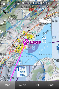
Air Navigation Pro supports geo-referenced approach charts that can be opened directly over the map.
We offer a 1-year-subscription package that includes:
- Geo-referenced Approach Charts to be used on the map.
- Approach Charts PDF documents (with additional info).
- Regular updates according to the Amendment cycles.
To purchase a subscription, read the article Installation.
