Difference between revisions of "Route planning/es"
(Created page with "<u>'''Nota:'''</u> para encontrar un waypoint cerca de un aeródromo, pueden utilizar la siguiente expresión: W@LSZG (waypoint id@airfield id). Esto obligará Air Navigation...") |
(Created page with "File:appimage.jpg Es posible '''crear un nuevo waypoint''' presionando durante dos segundos en su posición del mapa. Una ventana emergente le preguntará si desea agregar...") |
||
| Line 62: | Line 62: | ||
[[File:appimage.jpg]] | [[File:appimage.jpg]] | ||
| − | + | Es posible '''crear un nuevo waypoint''' presionando | |
| + | durante dos segundos en su posición del mapa. Una ventana emergente le preguntará si desea agregar este punto en la base de datos o simplemente usarlo como un waypoint “temporario” para dirigirse hacia allí. | ||
[[File:summary.jpg]] | [[File:summary.jpg]] | ||
Revision as of 18:06, 23 October 2015
Contents
Android version

By default, the moving map is in «Flight mode». You can toggle the moving map from «Flight mode» to «EDIT MODE» at any time to create or amend a route by pressing on the «Edit» button in the Toolbar.

To create a route:
- Toggle to «edit mode», a yellow-and-black striped bar should appear at the top of the moving map. A search field will also appear on top of the «Route module».
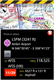
- To Add waypoints to your route, press on waypoints of your choice on the moving map. In the waypoint popup, press on the «add» option. A yellow star should appear on the moving map and your waypoint should be in the «Route» list.
- Alternatively, you can input one or more waypoint identifiers in the «search» field on top of the «Route module» and press on “search”. Multiple identifiers must be separated by a space:


In edit mode it is also possible to remove waypoints from the list in the «Route module». Alternatively, you can remove a waypoint by pressing on the map and choose the «remove» option.
It is possible to insert a waypoint by pressing on, holding and dragging the magenta vector (leg) and moving to a new location on the

map. As a result, a new waypoint will be inserted in the «Route». If the location on the map is not over an existing waypoint, a «temporary» waypoint will be created named “user waypoint”. In the «Route module», you can press on the «Summary» line at the top of the list to write the route name and cruise speed. The

route name is used to identify a particular route in the «Routes list» when they are saved. Cruise speed information will be used to display ETA on top of the list.


When you are satisfied with your route, you can toggle back to «Flight mode», and the route will be automatically stored in the «Routes list» (see screenshot on the left).
On the left-side screenshot you can see 3 routes stored as an example.
By selecting any of them from this module, Air Navigation Pro will take it as the current route on the moving map.

In order to Reverse the Route, you should press on the upper-right button of the «Route module» as shown on the screenshot.
You will have the options to save the current Route as a new one, send it by e-mail and also to import a GPX file as a new route.

When switching back to «Flight mode», you will show on the next waypoint of the list the bearing (BRG) and magnetic course from your current position.
iOS version
Por defecto, el mapa móvil está en «modo de vuelo». Es posible cambiarlo de «modo de vuelo» a «modo planeamiento» en cualquier momento, con el fin de crear o enmendar una ruta presionando el botón «EDIT» de la barra de herramientas.
Para crear una ruta:

- Cambie a «Modo Editar», una barra con rayas amarillas y negras debería aparecer en la parte superior del mapa móvil. Un cambio de búsqueda también aparecerá en el módulo «Rutas».
- Para agregar waypoints, presione sobre waypoints de su elección en el mapa móvil. En la ventana emergente, seleccione la opción «Agregar a la ruta». Una estrella amarilla debería ser vista ahora en el mapa móvil y su waypoint debería incluirse en lista del panel de «Rutas».
- Alternativamente, se puede entrar uno o varios identificadores de waypoints en el campo de búsqueda del módulo «Rutas» y presionar retorno. Identificadores múltiples tendrían que estar separados por un espacio.
Nota: para encontrar un waypoint cerca de un aeródromo, pueden utilizar la siguiente expresión: W@LSZG (waypoint id@airfield id). Esto obligará Air Navigation a encontrar los wayponts más cercanos desde LSZG hasta el identificador W, como ejemplo.
En el modo Editar también es posible reordenar y remover waypoints de la lista del módulo «Rutas». Alternativamente, se puede remover un waypoint presionando sobre el mismo en el mapa y eligiendo la opción «Borrar de la ruta». Es posible agregar un waypoint presionando sobre el vector color magenta (pierna) y arrastrándolo a una nueva posición en el mapa. omo resultado, un nuevo waypoint será insertado en la «Ruta». Si la posición del mapa no se encuentra sobre un waypoint existente, un waypoint «temporario» será creado. Tiene la opción de agregar este waypoint temporario luego en la base de datos, si desea hacerlo.
 Es posible crear un nuevo waypoint presionando
durante dos segundos en su posición del mapa. Una ventana emergente le preguntará si desea agregar este punto en la base de datos o simplemente usarlo como un waypoint “temporario” para dirigirse hacia allí.

In the «Route» module, you can press on the «Summary» line at the top of the list to set the route name and wind. The route name is used to identify a particular route in the «Route» list when they are saved. Wind and cruise speed information will be used to display estimated time and heading in «edit mode». In «flight mode» current speed as reported by the GPS will be used to compute estimated time. The button at the top right corner of the window can be used to reverse the route or duplicate it. When you are satisfied with your route, you can toggle back to «flight mode», the route is automatically stored in the «Routes list».
Back to index (Android)
Back to index (iOS)
