Difference between revisions of "Map Options menu"
Jump to navigation
Jump to search
(Created page with "--- From the «Toolbar» press the «Map Options» button to access various options for the moving map: frame * '''Brightness.''' Controls the brightne...") |
|||
| Line 1: | Line 1: | ||
| − | --- | + | ---- |
From the «Toolbar» press the «Map Options» button to access various options for the moving map: | From the «Toolbar» press the «Map Options» button to access various options for the moving map: | ||
[[File:mapoptions.jpg|frame]] | [[File:mapoptions.jpg|frame]] | ||
Revision as of 16:56, 18 August 2015
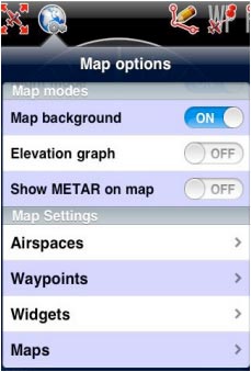
From the «Toolbar» press the «Map Options» button to access various options for the moving map:

- Brightness. Controls the brightness of the screen.
- Show maps. Enables or disables the screen background.
- Elevation graph. Enables or disables the terrain elevation
view.
- Terrain awareness 2D/3D. Enables or disables the terrain
awareness for both moving map and 3D EFIS module.
- Show METAR on map. Displays icons over the Airports
according to the weather conditions (VMC/IMC) on the map. Internet connection is needed to use this feature.
